A Visual History: The Huge Map on View in Armenia!
The Tabula Chorographica Armenica on view in the exhibition gallery. Photo by Sumi Hansen
Among the spectacular objects that greet visitors to Armenia!, on view at The Met Fifth Avenue through January 13, 2019, is the Tabula Chorographica Armenica, a magnificent seventeenth-century map on loan from the Biblioteca Universitaria in Bologna, Italy. This map was created by two remarkable players in the dynamic political and cultural arena of the late 1600s: Eremia Chelebi K’eomiwrchean, the Armenian intellectual, poet, and historian, and Luigi Ferdinando Marsili, who was a scientist and cartographer as well as an Italian diplomat and military man. The two men met in 1691 during the wars between the Habsburg and Ottoman Empires. This article tells the story of the map, which was the fruit of their intellectual collaboration.
The Tabula Chorographica Armenica was commissioned by Count Marsili, an Italian nobleman who lived a life worthy of an action movie. Marsili was sent to Constantinople in 1691, a moment when Vienna had opened peace talks with the Ottomans as part of the Austro-Turkish conflict. It was the thirty-three-year-old aristocrat's second visit to the city, which he had seen eleven years before as a member of the entourage of the ambassador Pietro Civran. He had spent eleven months in the city on his first visit; and since he hadn't been engaged in official tasks, he'd been able to devote himself to cultivating personal scientific interests, particularly in the areas of geography and the natural sciences. Much busier on his second visit in 1691, he was traveling undercover as secretary of the British Ambassador, William Hussey. His goal was to find a window of opportunity for peace.
Nicola and Ottavio Toselli. Commemorative Bust Dedicated to the General Luigi Ferdinando Marsili Dressed as a Roman General (detail), 1766. Italian. Marble with wood and gilding. Museo di Palazzo Poggi
The map was produced by K‘eomiwrchean, the secretary of the Armenian Patriarchate of Constantinople and one of the key personalities of Istanbul's Armenian community. A prominent figure in Armenian historiography, he promoted the establishment of the second Armenian printing house in Istanbul and left behind a great literary heritage, including historical-geographical works; topographical works, such as this map; and dogmatic-polemical texts; as well as letters, lamentations, canticles, verses, and odes.
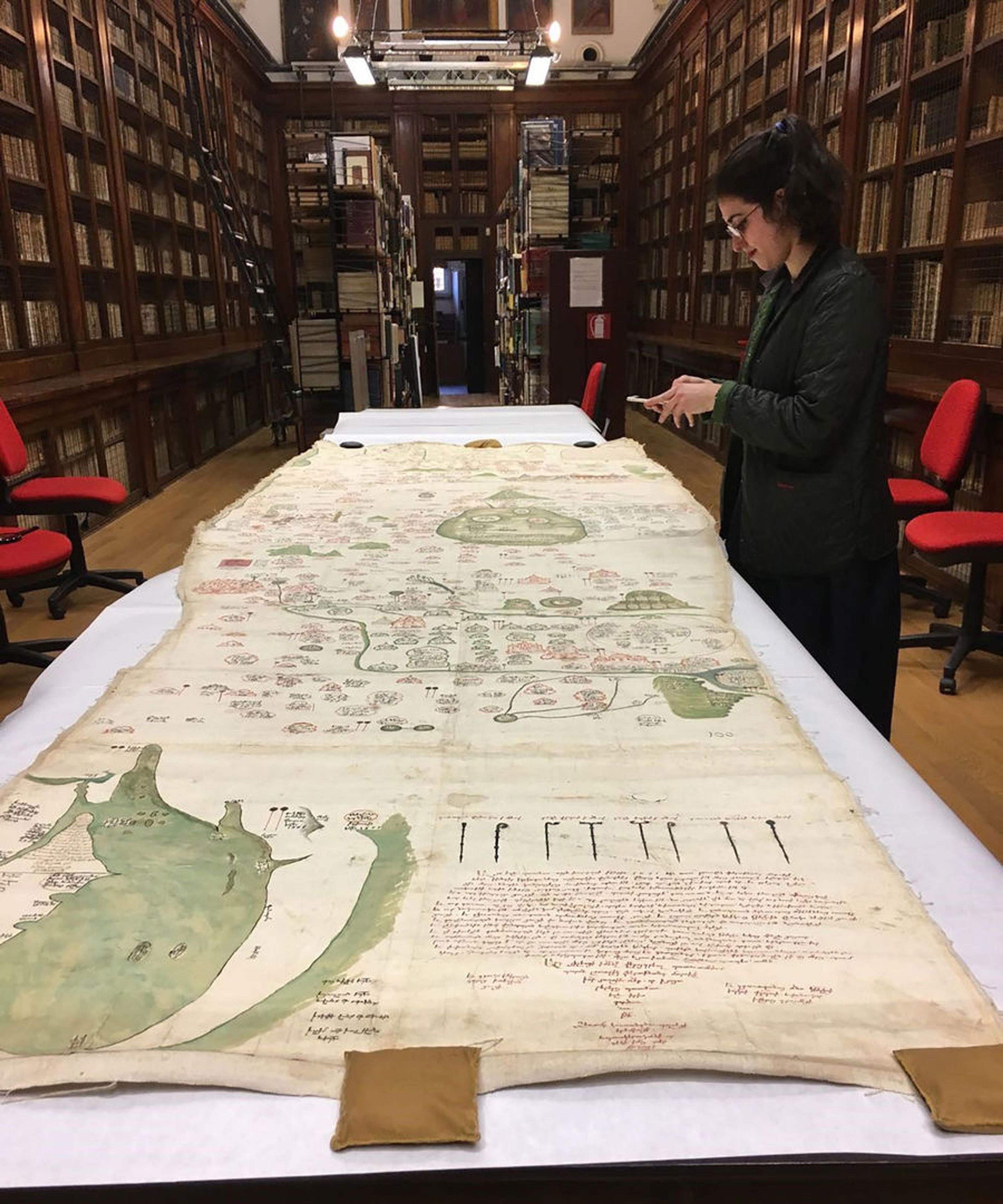
Tabula Chorographica Armenica, 1691. Armenian. Made in Constantinople. Tempera and ink on paper, 47 1/4 in. x 11 ft. 9 in. (120 x 358 cm). Biblioteca Universitaria di Bologna, Fondo Marsili, Italy
The map is huge—almost 4 by 12 feet (or roughly 120 by 358 centimeters)—and incredibly detailed. It was clearly not meant to be used as a traveling tool; its unwieldy size and its organizational scheme—which defies topographic logic—make it impossible to use as a guide to movement. A visual document that stands as a compendium of Marsili's vast knowledge and wide-ranging travels, it highlights the history even more than the geography of the Armenian territories.
Having studied at the prestigious university in Bologna with leading scientists, including Marcello Malpighi, Geminiano Montanari, and Gian Domenico Cassini, Marsili had a rich correspondence with foreign scientific eminences, such as Robert Hooke and Isaac Newton of the newly formed Royal Society of London. Marsili used his scientific talents energetically to deepen knowledge of the entire Danube region. In his hands, maps and geological and hydrographic profiles became real scientific instruments, as well as strategic and diplomatic documents.
Marsili's Tabula Chorographica Armenica was intended to show the broad reach of the Armenian Church under the Ottoman Empire. Even more than a topographical record, the Mappa Marsili is a symbolic representation of history in two dimensions.
Video of the map being unrolled for the exhibition
This luxurious large map shows the expansiveness of the Armenian Church in the late seventeenth century. K‘eomiwrchean illustrated nearly eight hundred sites on the map, including the major Armenian ecclesiastical centers: the catholicosates of Etchmiadzin, Gandzaar, Aght‘amar, and Cilicia; and the patriarchates of Jerusalem and Constantinople. Also depicted are important churches and sites in the Ottoman Empire—all the way from Nishapur, the location of the martyrdom of Lewondeank, to the churches and monasteries of Crimea.
Detail of Tabula Chorographica Armenica, showing Etchmiadzin Cathedral at left
In one striking scene, priests and men in contemporary Ottoman dress can be seen conversing in front of Etchmiadzin Cathedral. The inscription explains the history of the cathedral's establishment in the fourth century by Saint Gregory the Illuminator, as recorded by the Armenian historian Agat‘angeghos. To the right are the twin peaks of Mount Ararat, in green.
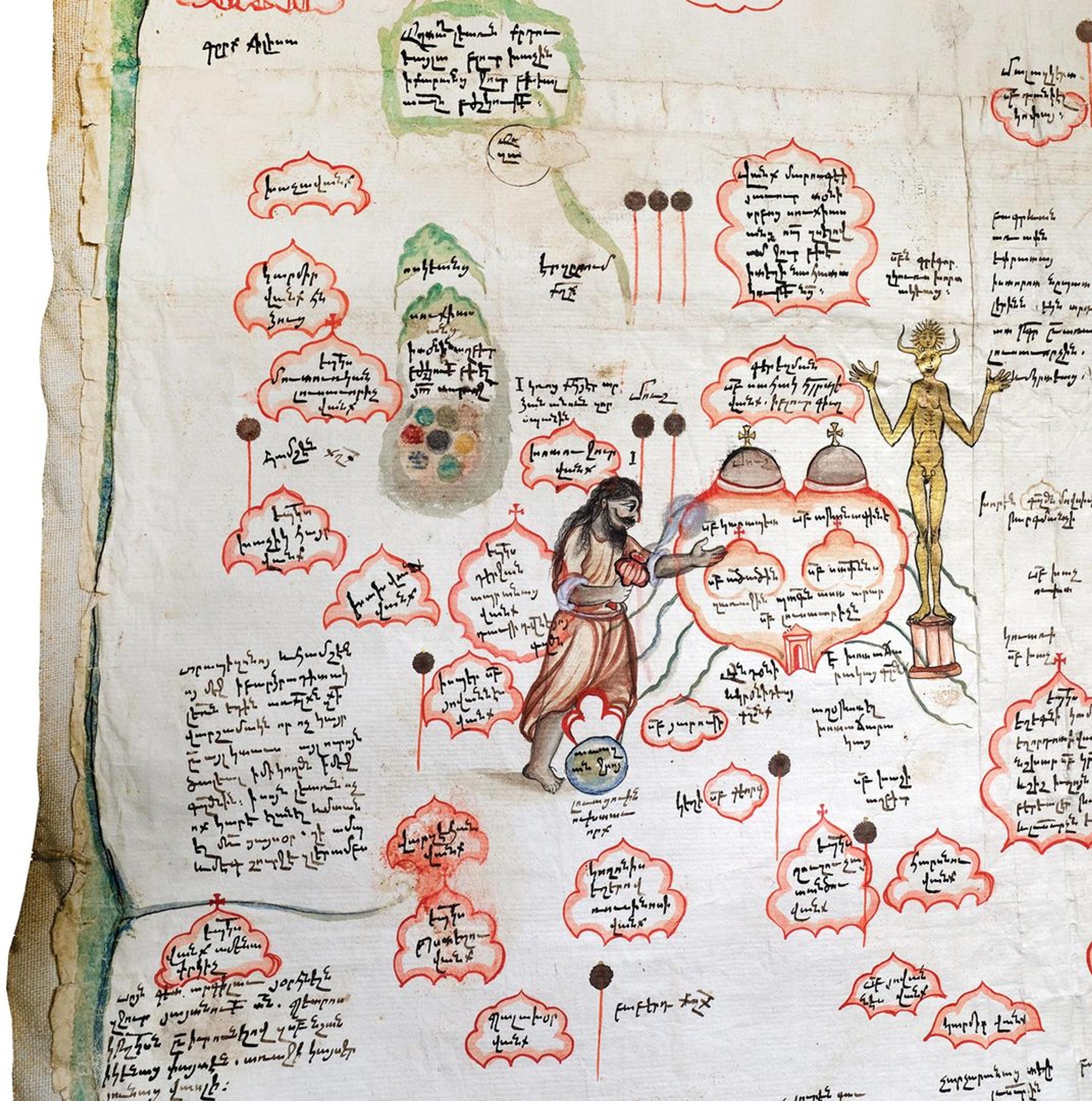
Detail of Tabula Chorographica Armenica, showing Saint Gregory the Illuminator waving a censer with incense to banish the idols
In another scene, Saint Gregory the Illuminator, bearded and wearing pantaloons, is shown banishing the idols from Mush. The symbols resembling lollipops are called tugs. These tugs indicate the importance of a city to the Ottoman court. The town of Mush has two tugs, and Erzrum has three, indicating the towns' relative rank in the Ottoman sphere.
Notwithstanding its importance, the map disappeared just a few years after Marsili returned from Constantinople to Bologna. The Count probably first displayed it in the Library of the Istituto delle Scienze; in 1712 he donated it to the university along with other travel mementos. From then on its whereabouts were unknown to scholars who sought to consult it. As a result, Armenologists first began to look for it in Vienna, since it was known that Marsili had spent time there. Only in 1991, three hundred years after its creation, did Gabriella Uluhogian, professor of Armenian studies at the University of Bologna, locate the map in the collection of the Biblioteca Universitaria.
The author viewing the map in the University of Bologna Library, in October 2017
Since its "discovery" in the University Library, the map has been published, reproduced in facsimile, and occasionally unrolled for scholars to examine. I had the privilege to admire it in March 2016, when I went to Bologna to participate in preliminary discussions for the loan of the map. In the spring of 2018, the map was restored for the first time in its history in preparation for its first transatlantic flight. A non-invasive conservation procedure was performed to consolidate losses in the paper and to reattach the eight sheets of paper to their muslin backing. The entire restoration process was completed by Melania Zanetti in three weeks and in full view of the public at the Palazzo Poggi Museum.
On the day that Armenia! opened, almost three thousand people visited the galleries. Many of the visitors were of Armenian descent. They pored over the map to identify villages, cities, monasteries, and churches inhabited or frequented by their ancestors. As they gazed at the map, a bridge was built between a world three hundred years in the past and today's New York—one of those memorable moments at The Met when history truly comes alive.
Related Content
Armenia! is on view at The Met Fifth Avenue through January 13, 2019.
Visit the places mentioned in this article on The Met's Interactive Map of Armenians in the Medieval World.
View the galleries in the exhibition's digital walkthrough.
Listen to the Audio Guide for the exhibition.
The exhibition catalogue is available at The Met Store.