On loan to The Met The Met accepts temporary loans of art both for short-term exhibitions and for long-term display in its galleries.
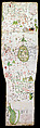
Tabula Chorographica Armenica
Not on view
This large map, a luxury display object for elite merchants and scholars, shows the expansiveness of the Armenian Church in the late seventeenth century. K‘eomiwrchean illustrated nearly eight hundred sites on the map, including the major Armenian ecclesiastical centers: the catholicosates of Etchmiadzin, Gandzaar, Aght‘amar, and Ciliica, and the patriarchates of Jerusalem and Constantinople. Also depicted are important churches and sites in the Ottoman Empire from Nishapur, the location of the martyrdom of Lewondeank, to the churches and monasteries of Crimea.
Priests and men in contemporary Ottoman dress sit conversing in front of Etchmiadzin Cathedral. The inscription below explains the history of the cathedral’s establishment in the fourth century by Saint Gregory the Illuminator as recorded by the Armenian historian Agat‘angeghos. To the side are the peaks of Mount Ararat in green.
Saint Gregory the Illuminator, bearded and wearing pantaloons, is shown banishing the idols from Mush. The symbols resembling lollipops are called tugs; they indicate the importance of a city to the Ottoman court. For example, the town of Mush has two tugs and Erzrum has three tugs, indicating their relative rank in the Ottoman sphere.
This image cannot be enlarged, viewed at full screen, or downloaded.

This artwork is meant to be viewed from right to left. Scroll left to view more.

